Reykjanes Without Lava

Liam Reilly
| 05-11-2026
 · Travel team
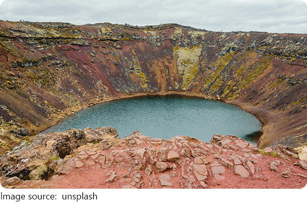
The volcanic terrain on the Reykjanes Peninsula, southwest of Reykjavík, contains eruption sites formed during the activity that began around Fagradalsfjall in 2021 and continued across the peninsula in later years. For Lykkers, the crucial distinction is between visiting an old eruption landscape and chasing an active eruption.
Access can change rapidly whenever new activity occurs, so this guide focuses on the more practical option: hiking the established Fagradalsfjall area when authorities have it open.
Choose the Right Trail
There is no single volcano walk here. Different paths lead to different eruption areas, and choosing the longest route simply because it reaches farther is often unnecessary.
Start With Path C
For a manageable first visit, Path C toward Langihryggur is approximately 4 km each way. It provides elevated views across eruption landscapes from 2021, 2022, and 2023 without requiring the longest hike in the area.
Plan roughly 3 to 4 hours for the complete outing, including stops. The terrain includes gravel, uneven ground, and exposed sections, so this is still a proper hike rather than a paved viewpoint.
Path A is another option for the 2021 and 2022 eruption areas. Depending on the exact route and parking point, it runs approximately 6 to 8 km one way and can require 2 to 2.5 hours just to hike in.
Path E toward the 2023 Litli-Hrútur eruption area is the serious version: roughly 18 to 20 km return and around 5 to 6 hours of walking before adding substantial viewing time. Choose it only if distance itself is part of the experience.
For most first-time visitors, Path C offers the better time-to-effort ratio.
Budget ISK 1000 for Parking
The established Fagradalsfjall parking areas charge approximately ISK 1000 per vehicle, with payment covering 24 hours.
There is no separate hiking admission fee, so self-driving keeps this relatively inexpensive. If two people share a car, the essential attraction cost is only about ISK 500 each before fuel and food.
The eruption area is roughly an hour from Reykjavík by car, depending on your starting point and conditions. A rental car is useful because you can postpone the hike when weather or gas conditions are poor rather than being locked into a fixed sightseeing window.
Guided excursions cost considerably more but become worthwhile if you are uncomfortable navigating exposed Icelandic terrain or do not want to rent a vehicle. For independent travelers with proper hiking equipment, a guide is not normally required for an open marked trail.
Check Conditions That Morning
This is one destination where planning several weeks ahead cannot tell you whether you should hike on the actual day. Access, weather, volcanic gases, and new activity can all change the answer.
Use a Three-Check Rule
Before leaving Reykjavík, check three things: whether your intended trail is officially open, the weather forecast, and volcanic gas or air-quality conditions.
If authorities close an eruption area, the decision is finished. Do not substitute an unofficial route.
Gas deserves particular attention because dangerous concentrations are not necessarily visible or easy to detect. Low terrain can collect volcanic gases, which is another reason to remain on designated paths and follow current instructions.
Never walk onto new lava. A surface that appears solid can conceal heat or cavities underneath, while volcanic rock itself can be extremely sharp.
Carry at least 1 to 1.5 litres of water per person for a shorter hike and more for Path E. Add food, waterproof outerwear, an insulating layer, gloves, and sturdy hiking shoes.
There are normally basic portable toilets around the main parking areas, but do not expect shops, drinking-water stations, or a developed visitor centre along the trail.
Skip the Hike When Necessary
Strong wind, heavy rain, poor visibility, ice, or an unfavourable gas forecast are all valid reasons to abandon the hike.
This matters because the landscape is extremely exposed. There are few places to escape deteriorating weather once you are several kilometres from the vehicle.
Avoid scheduling the volcano on the same day as a fixed international departure. Instead, place it near the beginning or middle of your Reykjavík stay so you can move it to another day.
A practical self-drive outing needs around 5 to 6 hours from Reykjavík when using a moderate trail: approximately 2 hours of return driving, 3 to 4 hours around the eruption area, plus a small buffer.
If conditions cancel the hike, keep the rental car and turn the day into a Reykjanes Peninsula drive instead. Geothermal landscapes and coastal viewpoints allow you to use the day without forcing an unsafe volcano walk.
Most importantly, do not travel to Iceland expecting to see glowing lava. Eruptions begin and stop unpredictably, and recently active areas may be inaccessible even when volcanic activity is visible elsewhere on the peninsula. Treat active lava as an unpredictable event, not something included in your itinerary.
For most Lykkers, the practical Reykjanes volcano experience is an established Fagradalsfjall hike rather than chasing the newest eruption. Path C offers a manageable option at roughly 4 km each way, while Path E reaches about 18 to 20 km return and requires around 5 to 6 hours of walking. Budget approximately ISK 1000 per vehicle for parking, allow 5 to 6 hours from Reykjavík for a moderate self-drive outing, and check trail access, weather, and gas conditions on the morning of the hike. If any of those three are unsuitable, change the plan rather than changing the safety rules.